Dates: 08/28 - 8/31
Start: Lescun (Gité)
End: Gavarnie (Hotel)
Distance: 62 miles
Vert: 27k+ / 25k-
I was excited to leave Lescun. While it was a picturesque village in the mountains, I knew I was just at the start of the aforementioned mountains and couldn’t wait to climb higher up. After a disappointing breakfast at the Gité (weak coffee, stale bread, and a single croissant), I made my way to the ski town of Candanchu. A refugio at the top of the first climb was closed for renovations, but to make up for it I ran into a British section hiker, Christopher, on the descent and walked with him for a bit. I dropped him shortly before Candanchu just as we met a group of five Basque guys doing a section of the GR11, with which the HRP overlapped for a bit here.
I hadn’t really planned to make it all the way to Candanchu but made surprisingly good headway. It was a busy day, as I briefly chatted with another HRP hiker from Spain who was both shocked I had left from Lescun and how much my gear had cost. He was brewing some coffee in an Aeropress and said he’ll hike as far as he gets before heading back to his job, but he was clearly in no hurry. It was my impression so far that most European hikers approach this whole hiking thing a bit more chill than thru-hikers on the major American trails. Hardly ever did I meet anyone doing 10-12 hour days (excluding yours truly, of course)


I decided to spend the night in Candanchu as hotels were cheap and I didn’t want to overdo it and get an overuse injury. I managed to meet up with Christopher again, shared a meal and some drinks, and had a great time just chatting. You always meet such interesting people hiking, and Christopher was no exception.
I left the hotel early the next morning and made my way over multiple passes again. The last few days there was always a threat of a thunderstorm hanging over us in the afternoon, and today was no exception. At around 4 pm it came down just as I was making my way up the final climb. I remember thinking that the storm probably won’t be too bad as the sheep were still grazing. Five minutes later I saw a Gandalf-like clad shepherd and his dog guide the flock of sheep down the mountain. So much for that. It started hailing.
I knew there was a technical section (Passage d’Orteig) waiting for me, and the guidebook mentioned a good spot to camp right after the pass. My plan was to set up my tarp and wait out the thunderstorm, but that plan had multiple flaws. First, the bivouac spot was quite bad, not very protected, and prone to flooding as I’d soon find out. Second, I was still very high up and it started lightning. Not really where you want to be.


So instead I decided to pack up again, keep hiking in the storm and look for a more protected site. Worst case I’d descend into the valley, but I also knew a refuge was supposed to be close by. Obviously, I couldn’t do the technical passage and instead bypassed it by first running down 800 ft, and then climbing the same distance back up. Thank god the storm lessened during the climb up, and I ran into yet another HRP hiker, Fancy, who I had briefly seen on the pass before. She’s an American living in Spain with her family and had hiked the PCT in 2018. We struck up a conversation and hiked the rest of the way to the refuge. While it was awesome to have met so many Europeans so far, we both had spent significant time on the West Coast so had a lot to chat about.


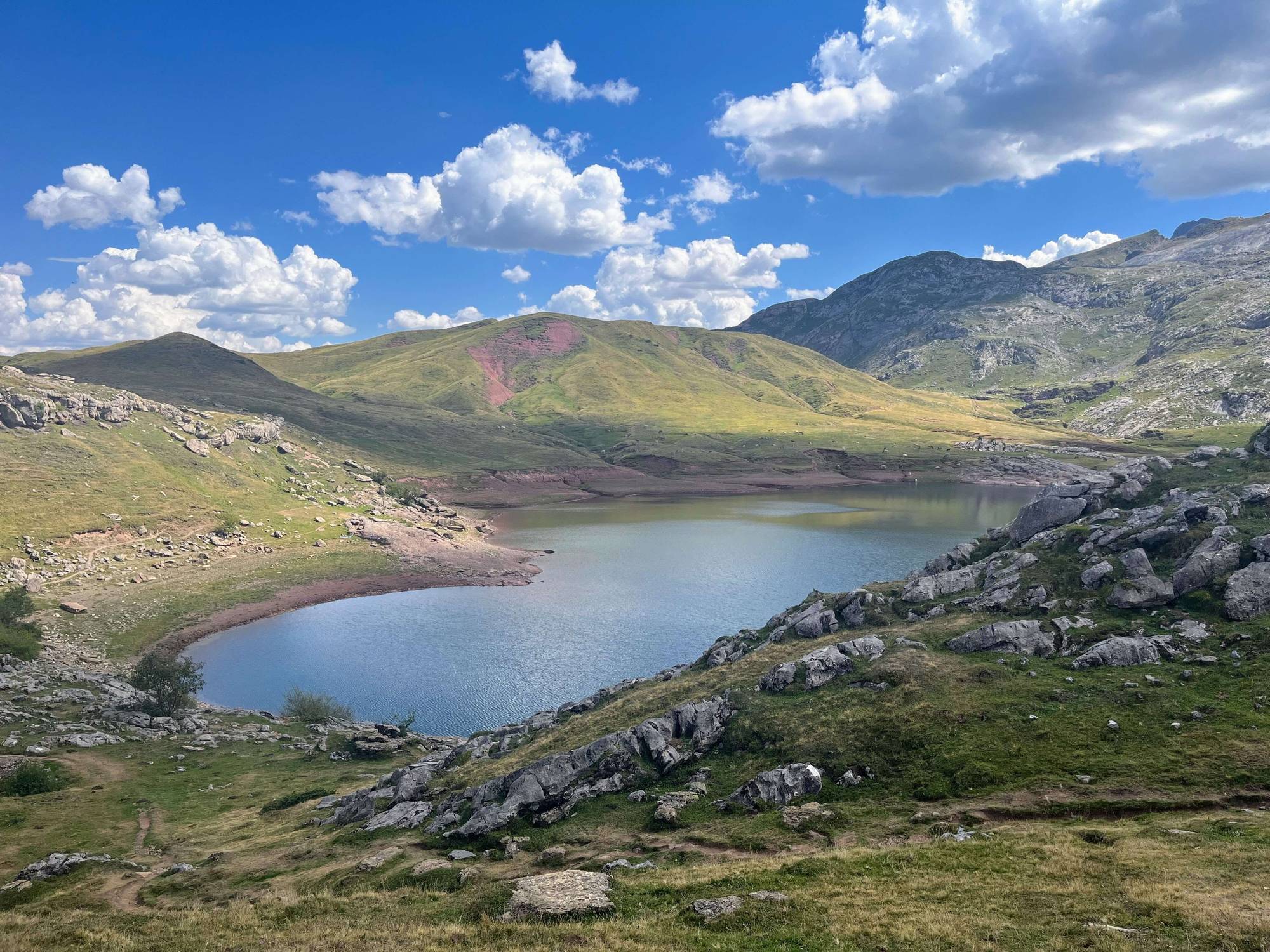
Lac d’Arrious. Had to pack up again because of a thunderstorm. The rock circles were common at camp spots.
The refuge was tiny, especially compared to some others I had seen so far, maybe only having space for 20 or so hikers. Given the weather, it was no surprise that it was crowded. We got there just at the right time for dinner, and once again the linguistic diversity was on full display with Fancy talking Spanish to the caretaker despite us being in France. I just stood there, nodding along sagely. During dinner, we shared a table with two older Dutch hikers who had also sought refuge (heh) from the storm, and we all decided to stay the night there. While there was still some room in the refuge proper, it was a cramped space of mattresses (the word hobbit hole was uttered), but luckily a big tent was set up outside where we could stay.
After the GDT, I really enjoyed this more social hike, especially as other hikers tend to be awesome. Case in point, I had run out of cash, which I only realized after crawling into my sleeping bag, but Fancy offered to pay and wouldn’t let me reimburse her later despite my offering multiple times (thanks again!!).
The storm was one of the worst I had been in, but nothing compared to the GDT snowstorm. The weather in the Pyrenees proved to be quite varied: from burning sunshine all day to hail in the afternoon. Something I made a note of to keep an eye out for in the coming days.


As the storm never really died down during the night, I struggled with sleep and the two tough days since Lescun showed themselves. The climbs now started to be more rocky and bouldery, gone were the days of nice smooth trails. My dairy says “I moved like a turtle”, and my initial plan of getting close to Gavanchie was defeated by my long afternoon nap. I’m a horrible napper, so when I actually manage to nap it’s usually a sign of fatigue and sleep deprivation. I passed some more Brits as I made my way past the massive Refuge Wallon (guessing 100+ beds) and called it a day early. It would turn out to be the only full day with less than 5000 ft of gain - I had done 8700 ft each the two days prior. Not exactly rocket science to figure out why I was tired.
For a reason I cannot recall I had decided to take an alternative route via the Col de La Fache, a beautiful yet long pass with three false summits. I’m definitely in the real mountains now.


The view down into the valley, with the massive Refuge Wallon. The refuge was brand new, huge, and incredibly ugly

I felt a little better the next day and despite having to go over three passes managed to find my way into Gavarnie, a touristy hotspot with lots of hikers and climbers. (Weeks later in Andorra, I’d read a travel diary by Kurt Tucholsky about his visit to the Pyrenees including Gavanchie, and it was impressive how little had changed in this town since the 1930s.) I had digestive issues all day and took a couple of Imodium tablets (anti-diarrheal) to prevent the worst. It’s not a thru-hike until you (almost) poop your pants.
Combined with the sad news that the weather had turned again (rain! Hail! Wind!) I decided to take a zero (rest day). I was ahead of schedule and there seemed worse places to relax.


Looking back at Lac d'Arratille, which is across the Col de Mulets. On the left is the Glacier Oulettes des Gaube on the northside of the Pic Vignemale, the highest French Pyrenean peak.


